


Glaciers in Peru’s Central Andes could disappear by the 2050s, a study says. A village in Checacupa, in the southern Cusco region of the Peruvian Andes, used to hold a ceremony to prepare a glacial lagoon to collect water, said Richart Aybar Quispe Soto, a local hospital worker. It was a ritual that honored the apus, the spirits of the mountains and water, he said. New research suggests that glaciers and water in the central range, closer to the capital, Lima, could suffer the same fate.
“In my mother’s village,” he said, “the glacial stream we call mayucha in Quechua no longer flows down the mountain.”
The central Andes could lose between 84 and 98 percent of its glaciers by 2050, a study predicts. After analyzing seven satellite images to determine changes in ice cover from 1990 to 2021 and developing a projection map based on climate characteristics and indices to identify areas most susceptible to glacier retreat, researchers from the University of Engineering and Technology in Peru found that complete disappearance is expected by 2056. Their findings were published last month in the Journal of Water and Climate Change.
“We have to adapt to the fact that the glaciers will disappear in 50 or 100 years,” said Pedro Rau, a hydrologist who led the study. Glaciers at lower altitudes are particularly vulnerable, he said.
Peru is home to about 68 percent of the world’s tropical glaciers. They are usually divided into three parts: northern, central, and southern. The glaciers in the northern Peruvian Andes have been studied extensively because of previous natural disasters, such as the 1970 Ancash earthquake, which triggered an avalanche.
In the southern range, around Cusco, they have received more international attention because of the cultural significance of the glaciers. But the glaciers in the central range, closer to Lima, have not been studied to the same level.
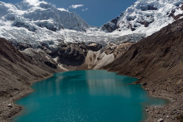
A view of Lake Palcacocha, a glacial lake in the Peruvian Andes near Huaraz, May 23, 2022. Angela Ponce/The Washington Post
Now, researchers have developed what they call a spatial projection map for 2021–2055 to understand what percentage of glacier loss to expect and what that means in terms of water access.
The study says that in Peru, glaciers are a strategic water resource for the country’s population and especially for Andean communities.
According to a 2023 government report, about 20 million Peruvians rely on water that flows from glaciers to some degree. Moshella explained that it’s not just the quantity of water, but also its quality. In the Cordillera Blanca, in the northern part of the range, the water levels are more acidic because the water flows through exposed rock previously covered by glaciers, according to the government report.
The loss of glaciers affects millions of people in Lima, and yet it’s hard to understand because the glaciers are far away, Rau explained, unlike in Cusco or the northern range, where people like Quispe Soto grew up much closer to glaciers. But at the end of the day, he said, “it’s still a national problem.”
Previous studies have focused on understanding glacier loss and dynamics, but this new study focuses on predicting and mapping future glacier conditions. Using these maps, researchers can understand the regions most affected by glacier loss, helping to make more informed decisions about water management.
Although glaciers are not usually associated with tropical weather, glaciers can be found in regions where there are high mountain ranges in the tropics, such as the Andes. Only a few regions of the world still have tropical glaciers due to their sensitivity to climate change. At lower latitudes, the length of the day does not vary much throughout the year, so tropical glaciers tend to melt faster without seasonal respite from the sun.
The rate at which tropical glaciers in Peru are melting is “alarming,” according to a study published in 2019. In fact, Peru has lost more than half of its tropical glaciers in the past 60 years, according to a government report published in October 2023.
The melting in Peru is part of a global acceleration in the decline of glaciers and ice sheets, with the rate of ice loss nearly doubling to 1.3 trillion tons per year since the 1990s and accelerating sea level rise, recent research has found. As a result, at the current rate of global warming, global average sea levels will rise 4 to 5 feet by 2100, a 2022 study says.
The new study adds to an existing body of research on glacier loss in Peru, as well as new studies of vulnerable regions and projections.
“These kinds of studies contribute to our knowledge of future scenarios,” said Paola Moschella, director of glacier research at the National Institute of Glacier and Mountain Ecosystem Research (INAIGEM) in Peru, who was not involved in the study. The institute oversees glacier monitoring at the national level and focuses primarily on historical glacier loss and risk assessment. These kinds of studies, conducted by researchers outside the institute, help researchers understand future glacier projections, Moschella explained. They also help raise awareness of how the impacts of glacier loss, such as water shortages, will be exacerbated, she said.
Regions like Cusco have seen an alarming increase in water shortages in the past couple of years, with the government warning of imminent drinking water shortages by 2023. Rau, the study’s author, was also part of a team of international researchers working on a project in Cusco that aimed to better understand and monitor glacier loss and ensure water security.
For people who have experienced water shortages like Quispe Soto, the loss of glaciers is troubling in many ways, not just in terms of water as a resource, but also in terms of the importance of glaciers as part of religion and culture. He worries that his son will not experience glaciers and water the way he did.
“When my father took me to the glaciers as a child, everything was white,” he said. “Today there are only black rocks.”
Glaciers in Austria are retreating on average by more than 20 m per year and could melt completely within the next 46 years, according to the glacier measurement service of the Austrian Alpine Club.
As the Austrian Press Agency reports with reference to the service, not one of the 90 glaciers in the republic is capable of supporting its own mass. “Austrian glaciers exist only thanks to the ice reserves accumulated in the past,” said the head of the service, Andreas Kellerer-Pirklbauer.
Due to melting, cracks and crevices appear on the glaciers, which makes it dangerous for people to be on them, the expert added.
Earlier, the Institute of Geography of the Russian Academy of Sciences told TASS that most of the Earth’s glaciers have significantly shrunk in recent decades. In particular, the area of glaciers in the northern part of the Sredinny Range and on the Kronotsky Peninsula of Kamchatka has decreased by 35.6% since 1950.
Venezuela has been left without glaciers, becoming the first country in the modern world to do so. Over the last century, the country has lost 6 glaciers. The last of the remaining ones, the Humboldt Glacier, also known as La Corona, was recognized as a static ice field, but it too has shrunk to two hectares.
A study cited by AccuWeather points to climate change as the main cause. According to a 2020 study, the area of Venezuelan glaciers has shrunk by 98% between 1952 and 2019. The retreat of glaciers peaked in 1998.
The Venezuelan authorities tried to preserve the glaciers, in particular using thermal blankets. However, this did not produce any results, and climatologists even reproached the government for polluting the environment.
The area of glaciers in the northern part of the Sredinny Range and on the Kronotsky Peninsula of Kamchatka has decreased by more than a third since 1950. This was reported to TASS by the press service of the Institute of Geography of the Russian Academy of Sciences.
Like most glaciers on Earth, Kamchatka’s glaciers have shrunk significantly in recent decades: in the northern part of the Sredinny Range and on the Kronotsky Peninsula, their area has decreased by 35.6% since 1950. At the same time, the average rate of glacier shrinkage in the northern part of the Sredinny Range from 2002 to 2016–2017 increased by approximately 4.3 times compared to the period 1950–2002, while on the Kronotsky Peninsula, the rate of glacier shrinkage has remained virtually unchanged at the beginning of the 21st century.
In the northern part of the Sredinny Range, the greatest reduction is observed in small glaciers with an area of less than 0.1 sq. km and in glaciers of the southeastern and southern parts. The main losses in glacier area in this region occurred in the altitudinal belt of 1200–1800 meters: 65.5 sq. km (25.2%) over the period from 2002 to 2016–2017. On the Kronotsky Peninsula, the greatest reduction in glacier area over 2000–2019 occurred at altitudes less than 500 m (55.1%) and in the range of 500–700 m (27.9%).
In addition, based on meteorological station data, a slight increase in air temperature of up to 0.3° over 10 years in the summer season and a decrease in precipitation in the winter season in the northern and northwestern parts of Kamchatka (on average by 5-10% over 10 years) were revealed. At the same time, a significant increase in the radiation balance was revealed in May-September against the background of a tendency to reduce cloudiness, mainly due to the lower tier cloudiness. All this indicates an increase in the frequency of anticyclones over the region in the warm half of the year, which, apparently, became the cause of the positive anomaly of the radiation balance. The increase in the frequency of anticyclones is probably a consequence of the so-called “expansion of the tropics,” the scientists note.
The obtained values of climate parameter changes were also used to estimate the shrinkage of the modeled Kamchatka glacier. Estimates of the glacier area shrinkage according to the Orlemans model were 22% over 20 years, which is consistent with observations in the northern part of the Sredinny Range.
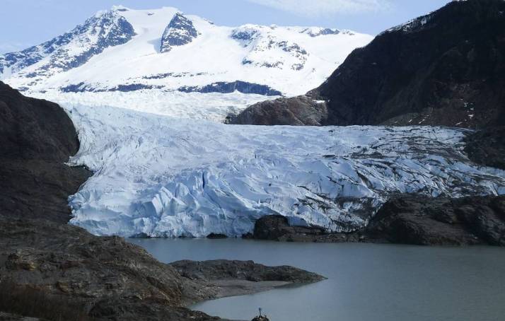
The area of Alaskan glaciers is shrinking five times faster than at the end of the 20th century. Climatologists previously assumed that the accelerated reduction in ice volume and area would begin only at the end of the 21st century
British and American climatologists have discovered evidence that the rate of ice loss in southern Alaska has increased approximately fivefold in the current decade compared to the same indicator in the late 1970s, the press service of the British University of Newcastle reported.
“The Alaskan ice fields are particularly vulnerable to global warming, as higher ambient temperatures affect their entire surface. In addition, the flat nature of these glaciers does not allow them to retreat into the mountains and find a new point of thermal equilibrium. In the future, these processes may lead to an irreversible retreat of these ice masses,” said Associate Professor Bethan Davis of the University of Newcastle, whose words are quoted by the press service of the university.
Scientists came to this conclusion while studying the state of the Juneau Ice Field, a large ice massif located in southern Alaska. Its total area is about 3.9 thousand square kilometers, and its length and width reach 140 and 75 kilometers. Scientists have been continuously monitoring the state of this ice field, many of whose glaciers have been rapidly retreating in recent decades, since the mid-20th century.
Climate scientists have been interested in how the glaciers have changed in the last few decades, as average Arctic temperatures have risen rapidly as a result of global warming. To get this information, the researchers analyzed and combined data collected by weather stations in Juneau and other parts of Alaska since 1941, and mapped the Juneau Ice Field using aircraft images taken in 1948 and 1979.
The researchers compared these maps and data with what the ice sheet looked like in satellite images taken by the Sentinel and Landsat climate probes between 1990 and 2019. This comparison showed that the area and volume of the Juneau Icefield had been shrinking steadily until 1979, but the rate of loss accelerated sharply in the following decades.
Specifically, the scientists found that the area of this ice mass has been shrinking about five times faster in recent years than it did in the late 20th century. Similarly, the volume of the Juneau field has been shrinking about six times faster in recent years (5.9 cubic kilometers per year) than it did before 1979 (0.65 cubic kilometers per year). These figures began to increase especially rapidly after 2005, reflecting the general pattern of climate change in the Arctic.
Such measurement results, as scientists note, are very different from current ideas about how the area and appearance of the Juneau ice field will change. Previously, climatologists assumed that the accelerated reduction in the volume and area of this ice massif would begin only at the end of the 21st century, but the data collected by scientists indicate that this process has already begun. This must be taken into account when assessing how the appearance of the Arctic will change as temperatures on Earth continue to rise, the researchers concluded.
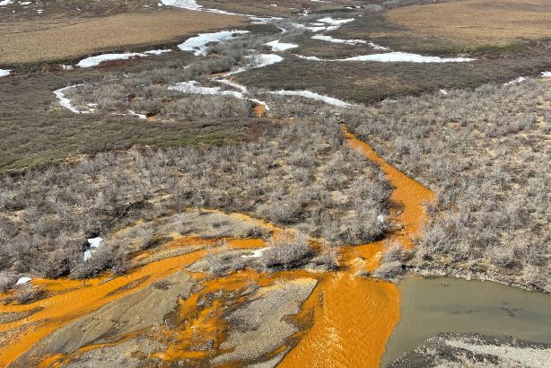
Once-clear waters in Alaska that have recently turned orange show high levels of iron and other metals, as well as increased acidity. In at least one stream, fish have disappeared. A 2024 paper published in the journal Nature Communications: Earth and Environment attributes these changes to rapidly thawing permafrost, which appears to be releasing metals like iron into these streams.
The iron particles make the stream very cloudy or full of particles, and then these particles often settle to the bottom of the stream, they coat the rocks and sediment at the bottom. But in addition to the iron, we see that these orange streams are more acidic, so they have a lower pH than clear streams. And there are a number of trace metals that are potentially toxic both in terms of drinking water and to the life that lives in these streams. Examples of these trace metals are zinc, copper, arsenic, cadmium and a number of others that are elevated in orange streams.
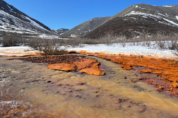
When permafrost melts, it changes the hydrology of watersheds. Metals can accumulate at the base of the food chain through algae and macroinvertebrates or insects that live in the stream bed and end up in fish, similar to what people have shown with mercury, which can bioaccumulate and increase in the food chain and then end up in fish and then in people if they eat fish.