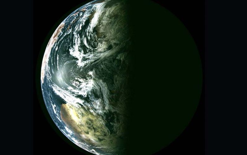
The Russian satellite constellation Arktika-M, launched in 2021 and 2023, transmitted the first images of the Arctic region and surrounding areas from space. On June 30, 2011, NASA’s Terra satellite made several passes over the Arctic. ICESat-2 is the second spacecraft to study the Earth’s ice cover. The US-India satellite NISAR will begin monitoring changes in the Earth’s frozen regions in 2024.
On January 15, 2024, the hydrometeorological spacecraft “Arktika-M” No. 2, during flight tests, received and transmitted to Earth the first images of the Arctic region and adjacent territories. The satellite is in an operational highly elliptical Molniya orbit with an equatorial inclination of 63.3 degrees, an apogee altitude of approximately 38,900 km and a perigee altitude of approximately 1,400 km. All of its service systems are functioning normally.

The first satellite of the highly elliptical hydrometeorological space system “Arktika-M” was launched into the target orbit in February 2021 and is performing its tasks in full. Two Arktika-M spacecraft will alternately replace each other in working sections of the orbits and will provide continuous round-the-clock visibility into the northern territory of Russia and the Arctic region, obtaining heliogeophysical information, relaying information from ground-based platforms for collecting meteorological data and transmitting signals to rescue services about the location of those in distress ships and aircraft in the interests of the international search and rescue system COSPAS-SARSAT.
Arktika-M is a planned constellation of four hydrometeorological satellites (until 2023, only two satellites were supposed to be part of the constellation) based on the Navigator platform and based on the equipment of the Electro-L series of satellites, which are designed to operate in a highly elliptical orbit of the Molniya type “(for the Arktika-M apparatus No. 1, the distance at the apocenter is 39425 km, at the periapsis – 1036).
Such an orbit allows them to continuously survey the northern (subpolar) territories of the Russian Federation and the Arctic, which cannot be done using only the existing geostationary satellites of the Elektro-L series. In 2021 and 2023, two Arktika-M satellites were launched from the Baikonur Cosmodrome. By 2031, it is planned to launch four more hydrometeorological satellites of this type.
The US-India NISAR satellite will also soon begin to study in detail how ice sheets, glaciers and sea ice are changing as climate change warms the air and ocean. NISAR, a soon-to-launch radar satellite from NASA and the Indian Space Research Organization (ISRO), will measure some of the Earth’s key vital signs, from the health of wetlands to soil deformation due to volcanoes and the dynamics of land and sea ice.

This latest opportunity will help researchers understand how small-scale processes can cause monumental changes in the ice sheets covering Antarctica and Greenland, as well as in mountain glaciers and sea ice around the world. Short for NASA-ISRO Synthetic Aperture Radar, NISAR will provide the most comprehensive picture to date of the movement and deformation of frozen surfaces in Earth’s ice- and snow-covered environments, collectively known as the cryosphere.
“On our planet, the thermostat is set to maximum, and Earth’s ice reacts by moving faster and melting faster,” said Alex Gardner, a glaciologist at NASA’s Jet Propulsion Laboratory in Southern California. “We need to better understand what is going on, and NISAR will provide the measurements to do that.” NISAR’s orbital orientation will allow it to collect data from the far depths of Antarctica, near the South Pole – unlike other large radar satellites that cover the Arctic more widely.
NISAR is scheduled to be launched by ISRO from southern India in 2024 to monitor almost all of the planet’s land and ice surfaces twice every 12 days. A unique view of the Earth’s cryosphere from the satellite will be obtained through the combined use of two radars: an L-band system with a wavelength of 10 inches (25 cm) and an S-band system with a wavelength of 4 inches (10 cm). L-band allows you to see through snow, helping scientists better track the movement of the ice underneath, while S-band is more sensitive to the moisture in the snow, which indicates it is melting. Both signals penetrate clouds and darkness, allowing observations to be made during the months-long polar winter nights.
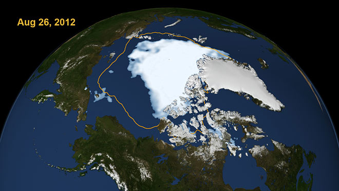
On June 30, 2011, NASA’s Terra satellite made its first few passes over the Arctic. As a result of arranging the images, it was possible to obtain a complete picture of the summer Arctic. In this mosaic, the polar ice cap appears blue and white, while the ice covering the ground appears bright white. On August 26, 2012, sea ice mass in the Arctic was at its lowest level in 30 years. The illustration, created based on NASA satellite data, shows how much ice there was in Artik on that day. And the line in the figure shows the average volume of ice during the summer months, which has been recorded by scientists since 1979, when satellite monitoring of ice conditions in the Arctic began.

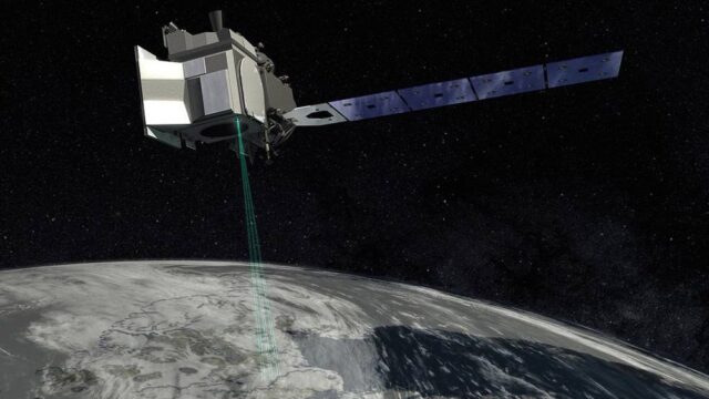
In 2018, NASA launched a new satellite, ICESat-2, into space that monitored the melting of glaciers in Greenland and Antarctica. ICESat-2 is the second spacecraft of its type to study the Earth’s ice cover. The previous one was launched in 2003, but then, due to technical problems, observations were carried out only for a few months a year. The new laser was able to track ice sheets as thick as a pencil lead. Such detailed data will help better predict changes in sea level, estimate the rate of melting of glaciers and the impact these processes have on the environment. This laser weighs almost half a ton. It became one of NASA’s largest vehicles at that time.

In addition, observations are also carried out from the ISS, for example, the Ekon-M experiment (photography of the Earth to assess the environmental situation).
At the bottom of this strait, many deep-sea buoys were installed that continuously monitor the properties of the ice floating or located above them, including its thickness, structure, speed of movement and other characteristics. Sumata and his colleagues obtained data collected by dozens of similar observation instruments between 1990 and 2019 while observing the state of ice in the Fram Strait.
Scientists’ analysis of this information showed that the structure of multi-year Arctic ice changed dramatically in 2007. Before this, the Arctic Ocean was dominated by deformed ice 3-4 m thick, and after that ice whose thickness was about 1-1.5 m began to predominate. Likewise, the average lifespan of ice changed sharply – it fell from 4.3 years up to 2.7 years.
The cause of the observed phenomenon was the abnormal “heat” in the Arctic in the summers of 2005 and 2007. This caused ice to melt off the coast of Siberia and Alaska and opened the way for warm water to the Arctic Ocean. As a result, multi-year ice has thinned and its lifespan has shortened.
Antarctica’s ice sheets are also of particular interest – they contain the planet’s largest reservoir of frozen fresh water, and the rate at which they can lose ice represents the greatest uncertainty in sea level rise projections. Expanding NISAR coverage will be critical to studying the movement of ice flowing from the highlands of central Antarctica to the sea.
The measurements will also allow scientists to take a closer look at what happens where ice and ocean meet. For example, when parts of an ice sheet are on land below sea level, salt water can seep under the ice and increase melting and instability. Both Antarctica and Greenland also have ice shelves – masses of ice that extend from land and float in the ocean – that thin and collapse as icebergs calve. Ice shelves help prevent glacial ice from sliding from land into the ocean. If they shrink, glaciers may flow and calve faster.
Sea ice in the Arctic has been declining for decades, and rising water and air temperatures are leading to increased melting. Because more of its surface is exposed to sunlight, the Arctic Ocean receives and retains more heat in the summer and takes longer to cool. That means less ice formation in the winter and faster melting the following summer, says Ben Holt, a sea ice scientist at the Jet Propulsion Laboratory.


