The rushing water turned narrow streets into death traps and created rivers that tore through homes and businesses, sweeping away cars, people and everything else in their path. The floods destroyed bridges and left roads unrecognizable. With record-breaking temperatures across the Mediterranean and a year’s worth of rainfall in a matter of hours, Spain was hit by a weather phenomenon known as DANA. A freak weather phenomenon known as DANA caused catastrophic flooding in Valencia, Spain in late October 2024. More than 155 people were killed and dozens more were missing in what meteorologists are calling one of the worst natural disasters in recent memory.
On October 29, some areas received the equivalent of a year’s worth of rain in a matter of hours, causing massive flooding that devastated entire towns and left thousands stranded. In some areas, rainfall reached 20 inches (500 liters per square meter).
The cause of this catastrophic weather is a phenomenon that forms in the Mediterranean called Depresión Aislada en Niveles Altos (DANA), a Spanish phrase that translates as isolated depression at high levels. It was the strongest DANA recorded in the 21st century, comparable to the disastrous “Pantanada de Tous” in 1982, according to the Spanish National Meteorological Agency (Aemet).
DANA is an enhanced version of a phenomenon known as a “cold slump,” which occurs when a mass of warm air collides with a stationary mass of cold air at an altitude of about 29,500 feet (9,000 meters).
There is a very strong wind current in the upper atmosphere that encircles the Earth like a belt. Sometimes this current begins to oscillate, more like a snake than a belt. When this happens, the oscillation can become stuck, allowing the mass of cold air to remain in one place. In this case, this happened over southeastern Spain.
DANA occurs when this cold air meets very warm air near the surface, especially over the warm waters of the Mediterranean Sea. This combination creates a significant temperature difference between the different layers of the atmosphere, which in turn causes the warm air to rise easily and become saturated with water vapor.
When this temperature contrast is combined with the humidity and energy of the Mediterranean, which becomes very warm after the summer months, the result is strong storms and torrential rains.
Oxford University geologist Yago Perez described DANA as one of the most dangerous meteorological phenomena in Spain, noting that “they release huge amounts of water in a very short time.”
Researchers say DANAs only form over Spain, but similar weather patterns called extratropical cyclones form in the Atlantic off the coasts of Uruguay and Argentina.
On October 29, DANA hovered over the same area for more than 12 hours, making it the most intense weather event of the day.
DANA encountered water temperatures of about 72 degrees Fahrenheit (22 degrees Celsius) off the coast of Valencia, while the typical temperature for this time of year is about 70 F (21 C). This difference may seem small, but it is enough to provide the storm system with additional energy. This can “cause a cascade of precipitation in a very short period, these rains can be described as monsoonal.
The Mediterranean Sea is one of the sea basins that has warmed the most in recent decades, acting as a “transmission belt” for moisture and energy. Since the 1980s, the average temperature in the Mediterranean has risen by 2.7 F (1.5 C) — nearly twice as much as the region’s air temperature increase over the same period. Since 2020, the Iberian Peninsula has seen record-breaking summer temperatures, with sea surface temperatures exceeding 84.2 F [29 C] this year.
This warming has changed the timing of DANA, with the Mediterranean now starting to warm in May and maintaining that warmth until November. By comparison, in the 1980s and 1990s, the event typically occurred in September and October. It is now estimated that 15 to 20 percent more DANA is produced each year compared to six decades ago.
Spain has been hit by record rainfall and flash floods, causing dozens of casualties, widespread destruction and economic damage in the latest in a series of floods that have hit communities across the globe. The region of Valencia has been the hardest hit, with many places receiving more than 300 mm of rain in 24 hours, and on the night of 29-30 October, the weather station in Chiva recorded 491 mm of rain in just 8 hours, equivalent to an annual rainfall, according to AEMET, the Spanish National Meteorological Agency. Jerez Airport in southwestern Spain saw a record 114.8 mm of rainfall in 24 hours on 30 October, a record for the station.
A massive rescue operation was launched as the death toll reportedly exceeded 150 people. Photos and videos showed people and cars being swept away by raging torrents of water, and buildings being destroyed. Tens of thousands of people in Valencia were left without power and transport was disrupted. The Spanish government declared three days of national mourning.
The AEMET agency, which is the official source of storm warnings in Spain, issued multiple alerts under the General Alert Protocol, the World Meteorological Organization (WMO) said. This included the highest level of yellow and red warnings for continued heavy rainfall in both eastern and southwestern Spain.
Other parts of Europe have also been hit hard by floods this year. In mid-September 2024, a very large region of Central Europe experienced very heavy rainfall, breaking local and national rainfall records. According to the Intergovernmental Panel on Climate Change, extreme weather events that cause severe floods and droughts have become more likely and more severe due to human-induced climate change. And this is confirmed by repeated events.
As a result of rising temperatures, the hydrological cycle has accelerated. It has also become more unstable and unpredictable, and humanity faces increasing problems with either too much or too little water. A warmer atmosphere holds more moisture, which contributes to heavy rainfall.
The cyclone named Dana that struck Spain took on the character of an isolated high-altitude depression. This happens quite often in the region in the autumn season, as residual surface heat from the summer clashes with a sudden cold intrusion from the polar regions. This leads to what meteorologists commonly call a blocking process, where low-pressure zones persist for several days over a region, unable to overcome the resistance of a larger anticyclone. As the climate changes, such situations are expected to become more intense due to warmer sea waters and increased atmospheric moisture. For every 1° of warming, saturated air contains an average of 7–9% more water vapor. This increase in atmospheric moisture increases the risk of extreme precipitation events.
Climate scientists at World Weather Attribution, an organization made up of experts from national meteorological and hydrological services, published a report on October 31 called “A Decade of Rapid Identification of Extreme Weather Events.” It showed how science has advanced enough to analyze the role of climate change in individual events. In a rapid analysis of Spain, the team calculated that rainfall was about 12 percent higher and twice as likely to occur compared to the 1.3° cooler pre-industrial climate. The findings align well with previous studies of extreme weather events in Europe, such as Storm Daniel and Storm Boris.
Scientists at World Weather Attribution have published other research showing that climate change has increased the intensity of rainfall and flooding this year in the Sahel and West Africa, East Africa, Asia (Nepal, India, Pakistan and Afghanistan) and southern Brazil.
However, research has shown that many other factors, including urbanization, land and water management, and poverty, also played a role in the disaster.
WMO’s updated State of the Global Climate 2024 report, to be released at the UN Climate Change Conference COP29 in Baku, Azerbaijan, will provide details of some of this year’s worst extreme events and their impacts.
The intense rainfall is due to a rare atmospheric phenomenon called a “cold drop,” meteorologists say, in which cold air moves over the warm Mediterranean, causing violent cloud formation and heavy downpours. Climate scientists, meanwhile, are quick to say that the climate crisis is making extreme weather events such as storms and droughts increasingly severe.
State and local authorities declared three days of national mourning as a sign of grief, and the Spanish Congress observed a minute of silence in memory of the victims. King Felipe VI of Spain expressed his support for the families.
Satellite images have captured deadly flooding in eastern Spain following heavy rains on October 29. Landsat and Maxar satellites captured the devastation after more than 30 centimeters (12 inches) of rain fell in the region, according to Spain’s meteorological agency AEMET. Landsat 8, the country’s operational land scanner, was scouring the area on October 30, tracking “sediment-laden waters” in the coastal city of Valencia, NASA officials said. (Landsat is jointly operated by NASA and the U.S. Geological Survey.)
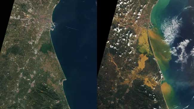
Landsat images of Spain show the country before and after devastating flooding in October 2024. NASA Earth Observatory, Lauren Dauphin, using Landsat data from the U.S. Geological Survey
“Sediment-laden floodwaters also filled the Turia River bed, which flows into the Balearic Sea – part of the Mediterranean – and the Albufera coastal wetlands south of the city,” NASA said in a statement.
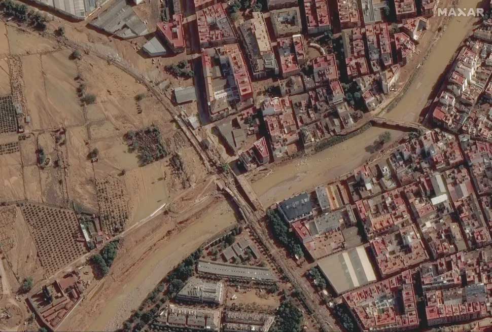
A canal in Valencia, Spain, as seen in this Maxar satellite image on October 31, 2024. Satellite image ©2024 Maxar Technologies
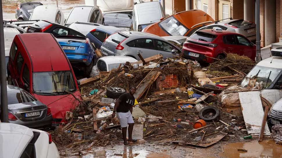
Rescuers searched for bodies in stranded cars and flooded buildings on October 31, 2024, as people tried to salvage what they could from their destroyed homes after monstrous floods in Spain claimed at least 158 lives, with 155 deaths confirmed in the eastern region of Valencia alone.
More horrors arose from the debris and ever-present layers of mud left behind by the walls of water that caused Spain’s deadliest natural disaster in living memory. The damage resembled that of a tsunami, and survivors were left picking up the pieces while mourning their loved ones.
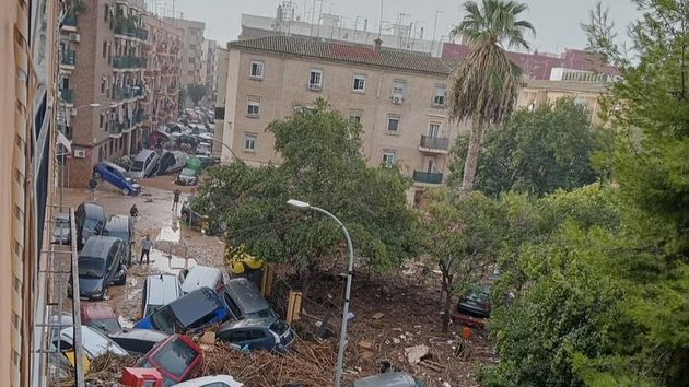
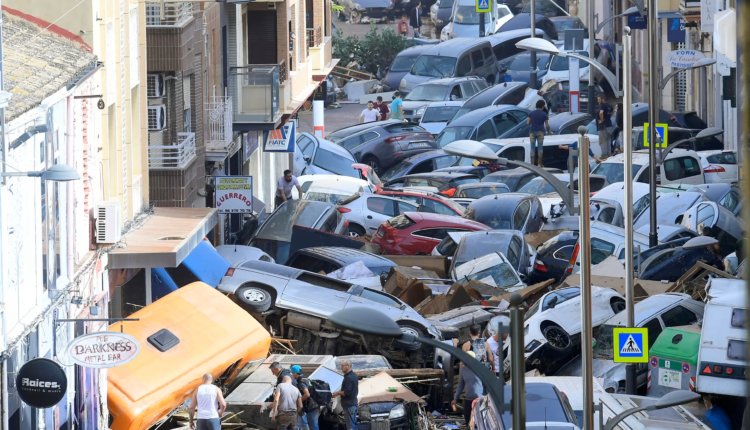
Cars were piled on top of each other like fallen dominoes, trees were uprooted, power lines and household items were stuck in the mud that covered the streets of dozens of towns in Valencia, a region south of Barcelona on the Mediterranean coast.
An unknown number of people are still missing and more victims may be found.
“Unfortunately, there are fatalities in some vehicles,” Spanish Transport Minister Oscar Puente said early Thursday, before the death toll rose sharply to 95 late Wednesday.
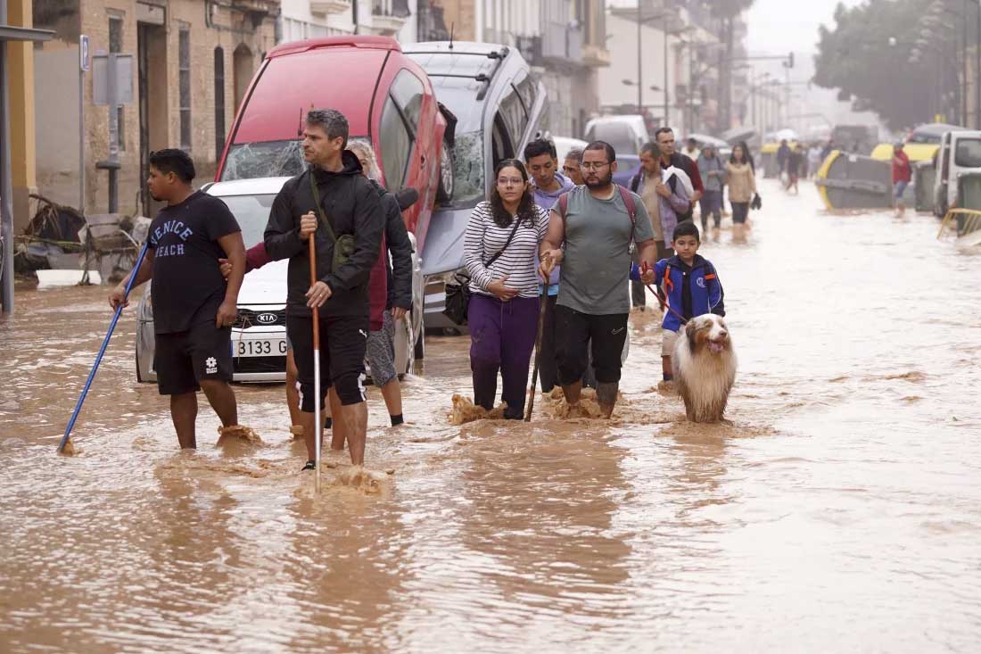
People walk through flooded streets in Valencia, Spain, October 30. Alberto Saiz/AP
The rushing water turned narrow streets into death traps and created rivers that tore through homes and businesses, sweeping away cars, people and everything else in their path. The floods destroyed bridges and made roads unrecognizable.
Welder Luis Sanchez was one of the lucky ones when a storm turned the V-31 highway south of the city of Valencia into a floating graveyard littered with hundreds of cars. He said he saved several people.
“I saw bodies floating by. I was screaming, but nothing happened,” Sanchez said. “Firefighters took the elderly people first when they were able to get in. I’m from nearby, so I tried to help and save people. People were crying everywhere, they were trapped.”
Regional authorities said Wednesday evening that no one appeared to be left on rooftops or in cars in need of rescue after helicopters rescued about 70 people. But ground services were far from finished.
“Our first priority is to find the victims and missing people so that we can help end the suffering of their families,” Spanish Prime Minister Pedro Sanchez said after meeting regional officials and emergency services in Valencia on Thursday, the first of three official days of mourning.
Spain’s Mediterranean coast is used to autumn storms that can cause flooding, but this was the worst flash flood in recent memory. Scientists have linked it to climate change, which is also behind Spain’s increasingly hot and dry seasons and a warming Mediterranean.

A man cleans his home damaged by flooding in Valencia, Spain, October 30. Alberto Saiz/AP
The worst casualties were in Paiporta, a community of 25,000 near Valencia. Mayor Maribel Albalat said Thursday that at least 62 people had died.
“(In Paiport) there are never any floods, we never have such problems. And we found a lot of elderly people in the city centre,” Albalat told national broadcaster RTVE. “There were also a lot of people who came to get their cars out of the garages… it was a real trap.”
While the worst hit municipalities were around the city of Valencia, the storms unleashed their fury on huge swathes of the southern and eastern coasts of the Iberian Peninsula. Two deaths were confirmed in the neighbouring region of Castilla-La Mancha and one in southern Andalusia.
Castilla-La Mancha regional president Emilion García-Page said at least one Guardia civil police officer was among several missing in the town of Letour.
Homes were left without water as far away as Malaga in Andalusia, where a high-speed train derailed on Tuesday evening, although none of the nearly 300 passengers were hurt.
Greenhouses and farms across southern Spain, known as the garden of Europe for its exported produce, were also devastated by torrential rains and flooding. The storms spawned a monstrous tornado in Valencia and hail that tore holes in cars in Andalusia.
The region remained partially isolated, with several roads closed and rail lines disrupted, including the high-speed link to Madrid. Officials said the damaged line would not be restored for two to three weeks.
The man wept as he showed a reporter from national broadcaster RTVE the shell of what was once the ground floor of his home in Catarroja, south of Valencia. It looked as if a bomb had exploded inside, destroying furniture and belongings and ripping paint from some walls.
The chaos also prompted some to smash and grab goods. National police arrested 39 people on Wednesday for looting shops in storm-hit areas. The Civil Guard deployed officers to stop the looting of homes, cars and shopping malls.
The severe weather event has surprised regional government officials. Spain’s National Meteorological Service said more rain fell in eight hours in the Valencian city of Chiva than in the previous 20 months, calling the deluge “extraordinary.”
But the relative calm of the following day also gave time for reflection and questions about the official response. The Valencia regional government has been criticised for not sending flood warnings to people’s mobile phones until 8pm on October 30, when flooding had already begun in some areas and after the national meteorological agency had issued a red alert for heavy rainfall.
Andreu Salom, the mayor of the Valencian village of L’Alcudia, told RTVE that at least two residents of his town had died – a daughter and her elderly mother who lived together – and that police were still searching for the missing truck driver. He also complained that he and the town’s residents had not been warned of the disaster, which occurred when the Magro River burst its banks on the evening of October 29.
“I went to check the river level myself because I had no information,” Salom said. “I went with the local police, but we had to turn back because the tsunami of water, mud, reeds and mud was already entering the city.”
Mari Carmen Perez said by phone from Barrio de la Torre, a suburb of Valencia, that her phone rang with a flood warning after a torrent of water had already broken through her front door and flooded the first floor, forcing her family to flee upstairs.
“They had no idea what was going on,” said Perez, the cleaner. “Everything is destroyed. The people here, we’ve never seen anything like this.”
Valencia regional president Carlos Mason defended his administration’s handling of the crisis, saying “all our leaders followed standard protocol.”


