Once upon a time, liquid water was abundant on the surface of Mars—oceans, lakes, and rivers—but it disappeared about 3 billion years ago; today, rovers explore dried-up lake beds and empty riverbeds. While some of Mars’s water is locked up as ice in the polar caps and as permafrost in the mid-latitudes, the rest of Mars’s water was assumed to have escaped into space. It was thought that atmospheric water vapor was destroyed by solar ultraviolet radiation, and Mars’s low gravity was thought unable to retain the hydrogen portions of this vapor, which would then be carried into space by the solar wind without the global magnetic field to protect it. Meanwhile, the oxygen portions of the vapor would have oxidized surface rocks, leading to the formation of the rusty-red planet we see today.
Dust and valleys
Although Mars, the Red Planet, is today a vast and inhospitable landmass, scientists believe it once resembled our Earth. Furthermore, experts argue that Mars once had a warm and humid climate, a belief based on striking geological features of this now-barren world, such as vast valley networks likely carved by streams. Furthermore, a new team of researchers has discovered evidence that it may have once rained, and even snowed, on Mars.
However, there is a significant mystery hidden in this story: it is unclear where water could have come from on Mars, and most climate models predict that the planet’s surface temperatures are too cold for liquid water to exist, raising the question of how these visible geological features could have formed.
“It’s very difficult to draw any definitive conclusions,” said Amanda Steckel, a research scientist in the Department of Geology and Planetary Science at the California Institute of Technology. “But we see that these valleys begin at high altitudes. It’s difficult to explain this solely by ice.” The team’s study was published on April 21, 2025, in the Journal of Geophysical Research: Planets.
Using computer simulations, Steckel and her team delved into what Mars might have looked like about 4 billion years ago during the Noachian epoch, when water could have dramatically transformed the planet’s surface. Their model, originally developed for Earth, was adapted to simulate the evolution of the Martian landscape near the equator. In this region, extensive networks of channels extend from highlands and flow into ancient lakes, possibly even an ocean. NASA’s Perseverance rover explored one such site, Jezero Crater, where a powerful river once flowed.
“It would take meters of water flow to deposit boulders like those seen in Jezero,” said Brian Hynek, senior author of the study and a scientist at the Laboratory for Atmospheric and Space Physics (LASP) at the University of Colorado Boulder.
Moreover, interestingly, hints of Mars’s temperate past can also be traced in Earth’s geological features. “If you were to open Google Earth images of places like Utah and zoom out, you’d see similarities to Mars,” Steckel said.
The team tested two main hypotheses for how Mars’ valleys might have formed under rainfall: one was when the planet was warm and wet, and the other was when ice temporarily melted at the edge of a large ice cap, representing a cold and dry climate.
Each scenario resulted in Mars looking completely different, with valleys forming in completely different places.
In the ice-melting model, valleys primarily formed at high altitudes, near where ice should have been. While this scenario might initially seem consistent with the characteristics of modern Mars, the warm and wet version resulted in much more extensive valley networks, forming everywhere from low-lying regions to more than 3,353 meters above the planet’s average surface.
The latter distribution better matches what we observe on Mars: a network of valleys scattered across many different elevations and regions. While the ice-melting model fits some local features, the warm and wet version helps explain the planet’s landscape on a global scale. “Water from these ice caps begins to form valleys only at a narrow band of elevations,” Steckel said. “Whereas, with precipitation distribution, valley tops can form everywhere.”
This suggests that precipitation played a significant role in the formation of these valleys, indicating that ancient Mars likely had a climate warm enough to support rain and even snow.
While further evidence and answers to questions such as how the planet remained warm enough for rain or snow are needed, the research is ongoing. Nevertheless, Hynek noted that the study provides valuable clues not only about Mars but also about the early history of Earth.
“Once the erosion caused by flowing waters stopped, Mars was virtually frozen in time and probably still looks much like Earth did 3.5 billion years ago,” he said.
Scientists, combining data from the European Space Agency (ESA) and NASA spacecraft with new laboratory experiments using a model of Martian dust, discovered that the Red Planet’s famous rusty dust has a much wetter history than previously thought. The results suggest that Mars rusted even in ancient times, when liquid water was more common.
Mars is easily recognized in the night sky by its bright red hue. Thanks to numerous spacecraft that have studied the planet in recent decades, we know that this red color is caused by rusty iron minerals in the dust. This means that the iron contained in Martian rocks at some point reacted with liquid water or water and atmospheric oxygen, similar to how rust forms on Earth, the ESA press service reported in February 2025.
Over billions of years, this rusty material—iron oxide—turned to dust and was carried by winds across the planet, a process that continues to this day.
But iron oxides come in different forms, and the precise chemical composition of Martian rust is a subject of heated debate, as how it formed provides insight into the planet’s environmental conditions at the time. Closely related to this is the question of whether Mars was ever habitable.
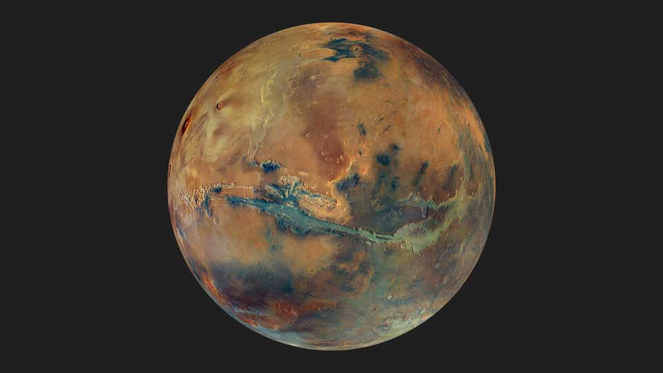
Martian mosaic in color. ESA
Previous studies of iron oxide in Martian dust, based solely on spacecraft observations, found no traces of water. Therefore, the researchers concluded that this particular type of iron oxide is likely hematite, formed under dry surface conditions through reactions with the Martian atmosphere over billions of years—following an early wet period on Mars.
However, a new analysis of space observations combined with new laboratory techniques shows that Mars’s red color is more consistent with water-containing iron oxides known as ferrihydrite. Ferrihydrite typically forms rapidly in the presence of cold water and therefore must have formed when water still existed on the surface of Mars. Ferrihydrite has retained its hydrous character to this day, despite being crushed and dispersed across the planet since its formation.
“We tried to replicate Martian dust in the laboratory using different types of iron oxide. We found that ferrihydrite mixed with basalt, a volcanic rock, best matches the minerals detected by spacecraft on Mars,” says lead author Adomas Valantinas, a postdoc at Brown University in the US who previously worked at the University of Bern in Switzerland, where he began his work with data from the European Space Agency’s Trace Gas Orbiter (TGO).
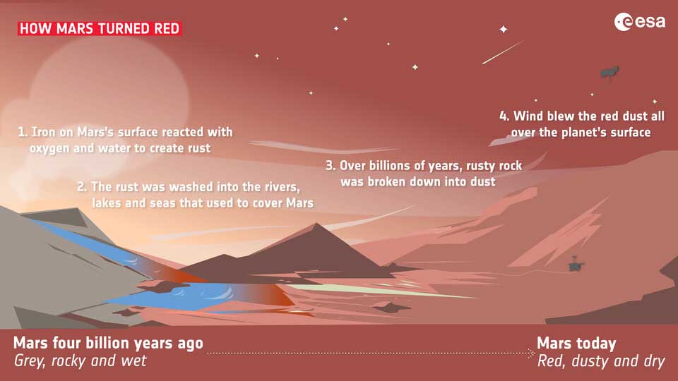
How Mars Turned Red. ESA
“Mars is still the Red Planet. It’s just that our understanding of why Mars is red has changed. The key finding is that, because ferrihydrite could only have formed when water was still present on the surface, Mars rusted earlier than we thought. Furthermore, ferrihydrite remains stable under modern conditions on Mars.” The results of the study were published in the paper “Detection of Ferrihydrite in Martian Red Dust Evidences Ancient Cold and Wet Conditions on Mars” in February 2025 in the journal Nature Communications.
Other studies have also suggested that ferrihydrite might be present in Martian dust, but Adomas and his colleagues provided the first comprehensive evidence using a unique combination of data from space missions and new laboratory experiments.
They created a replica of Martian dust using a state-of-the-art grinding machine to achieve a realistic dust particle size, equivalent to 1/100th the thickness of a human hair. They then analyzed the samples using the same methods used by orbiting spacecraft for direct comparison, and ultimately determined that ferrihydrite was the best analog.
“This research is the result of additional data sets obtained by a number of international missions studying Mars from orbit and the Earth’s surface,” said Colin Wilson, a project scientist for the European Space Agency’s TGO and Mars Express missions.
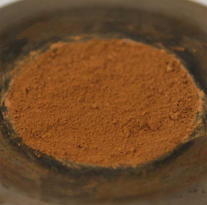
“Martian dust” created in a laboratory. ESA
An analysis of the dust mineralogical composition conducted by Mars Express helped demonstrate that even very dusty regions of the planet contain water-rich minerals. Thanks to the TGO’s unique orbit, which allows it to view the same region under different lighting conditions and from different angles, the team was able to determine the particle size and composition, which is essential for recreating the correct dust size in the laboratory.
Data from NASA’s Mars Reconnaissance Orbiter, as well as ground-based measurements by NASA’s Curiosity, Pathfinder, and Opportunity rovers, also helped confirm the existence of ferrihydrite.
“We look forward to the results of upcoming missions, such as ESA’s Rosalind Franklin rover and the joint NASA-ESA Mars Sample Return project, which will allow us to study further what makes Mars red,” adds Colin.
“Some of the samples already collected by NASA’s Perseverance rover and awaiting return to Earth include dust; once we get these precious samples back to the lab, we’ll be able to accurately measure how much ferrihydrite is contained in the dust and what that means for our understanding of the history of water—and the possibility of life—on Mars.”
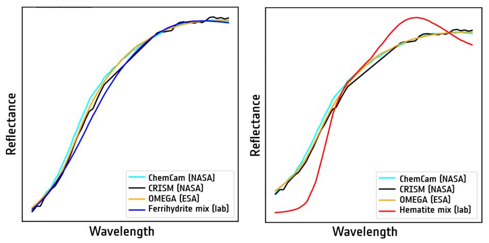
Ferrihydrite (left, dark blue) versus hematite (right, red) as an analogue of Martian dust. ESA
NASA’s Perseverance rover has found evidence of multiple interactions between water and rocks in Jezero Crater on Mars, including a period of hot groundwater activity.
Mars may have been a much wetter and geologically active world than it is today, with water constantly flowing through its rocks in various forms, according to a new study.
The discovery occurred in an area on the rim of Jezero Crater on Mars, known as the Marginal Site. NASA’s Perseverance rover has been exploring this region since 2023, and its observations have revealed evidence of at least three distinct episodes of water interacting with Martian rocks, including one involving the circulation of hot groundwater beneath the ancient surface, according to a statement from the space agency.
The “margin zone” region is adjacent to the inner rim of the crater and was identified based on orbital observations. Scientists initially predicted that Perseverance would encounter sedimentary rocks deposited along the shoreline of an ancient lake that once filled Jezero.
Instead, the rover discovered igneous rocks that originally formed from molten material deep underground or as a result of volcanic activity. This unexpected geological formation preserved a complex record of fluid activity. The results of the study were published on September 21, 2026, in the journal Communications Earth & Environment.
“Before we got to the main block, the hypothesis based on orbital observations was that the carbonate visible from orbit formed through interaction with a lake that existed in Jezero Crater,” said Candice Bedford, lead author of the study and a postdoctoral researcher at Purdue University in West Lafayette, Indiana, in a statement. “But now we know that this location was a crossroads of sorts for water systems. The results from the block study are important because Jezero Crater is located within one of the largest carbonate outcrops on Mars, so the knowledge gained here extends far beyond the crater.”
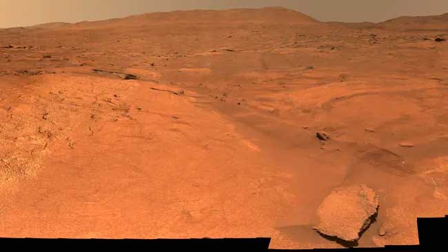
The Perseverance rover collected data used to create this panorama of the “rim site”—the geologic region adjacent to the inner rim of Jezero Crater—between October 8 and 16, 2023. NASA/JPL-Caltech/MSSS
Using Perseverance’s SuperCam instrument, researchers analyzed more than 185 bedrock samples from the Marginal Region. They found evidence that water altered the rocks over several periods.
During the first episode, carbon dioxide-rich groundwater reacted with olivine, a mineral formed during the slow cooling of magma. The reaction resulted in the formation of carbonate minerals in the rock’s cracks.
Apparently, a later episode was associated with the ancient Lake Jezero. Some rocks contain silica, which can form when olivine reacts with water and is especially abundant in rocks that once lay below the lake’s water level.
A third, hotter period followed. In the eastern part of the margin, mineral veins containing calcium sulfate and fluorite formed, indicating that hot water once circulated through the volcanic rocks.
On Earth, hydrothermal systems can create environments capable of supporting microbial life, making these ancient Martian water systems particularly interesting for scientists studying the Red Planet’s past habitability.
Although the researchers were able to reconstruct the sequence of these episodes, they cannot yet pinpoint exactly when each occurred. However, the sequence of events suggests that the block in the crater was more than just an ancient lakeshore. It was a site where groundwater, surface water, and heated fluids interacted with Martian rocks, potentially preserving a complex record of the evolution of the Martian environment over time—a record that the carbonate minerals in these rocks could help scientists determine when and where Mars might have once provided conditions suitable for life.
“If I’ve learned anything from 10 years of working with Mars rovers, it’s that Mars constantly surprises us,” Bedford said in a statement. “Very rarely does it turn out exactly as we expect based on orbital data. I hope this work will help rethink scientists’ understanding of the history of water in Jezero Crater and on Mars in general. Ultimately, I hope it will help planetary scientists reconstruct the climate and habitability of early Mars.”
More than 20 years after NASA’s Spirit rover began exploring Mars, scientists have discovered a hidden clue in its archival data that adds to growing evidence that the Red Planet was once rich in liquid water.
Researchers reanalyzed measurement data collected by the Spirit spacecraft between 2004 and 2010 and discovered widespread traces of crystalline hematite and altered magnetite in common Martian soil—iron-bearing minerals that indicate ancient chemical changes consistent with interactions between water and rock. According to a statement from Edith Cowan University (ECU) in Australia, these findings suggest that liquid water may have been more common on Mars than scientists previously thought. The study was published on June 26, 2026, in the journal Interactions.
According to the statement, the team combined hundreds of individual measurements taken at 32 pristine soil sites inside Gusev Crater, where Spirit landed in January 2004, creating the most detailed iron profile of typical Martian soil to date.
“One of the most important discoveries was the detection of crystalline hematite in common Martian soil,” said Paulo de Souza, lead author of the study and a professor at East Carolina University, in a statement. “The widespread occurrence of this mineral suggests not only the presence of water, but also that large areas of Mars may have once been covered by water.”
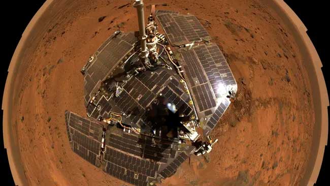
The Spirit rover on Mars. NASA/JPL-Caltech/Cornell
Crystalline hematite has long been considered one of the most compelling mineral indicators of the past presence of water on Mars. Although it can also form as a result of volcanic or hydrothermal activity, it most commonly forms through the interaction of iron-bearing rocks with liquid water.
This discovery is particularly significant because previous analyses concluded that crystalline hematite was virtually absent from the Spirit rover’s landing site. According to the researchers, the mineral’s signature was too weak to be discerned by individual rover measurements. However, by combining thousands of spectra collected during the mission, the team was able to isolate this signal from the background noise.
The researchers also discovered altered magnetite, suggesting that the original volcanic minerals in the Martian soil underwent chemical transformation over time. Together, altered magnetite and crystalline hematite provide further evidence that water played a significant role in shaping the planet’s surface. Since similar dust and soil cover much of Mars, these discoveries could have implications far beyond Gusev Crater, suggesting that water-related chemical processes may be more widespread across the planet than previously thought.
These findings add to growing evidence that Mars was once much more habitable than it is today. During its mission, Spirit discovered water-altered rocks and minerals in the Columbia Hills, and NASA’s Curiosity rover later found evidence that long-lived lakes once existed in Gale Crater. Most recently, Perseverance explored the remains of an ancient river delta inside Jezero Crater, where scientists hope to determine whether this environment could have once supported microbial life.
Besides revealing another chapter of Mars’s watery past, the study also highlights the enduring scientific value of spacecraft data long after the mission’s completion.
“This work shows that important discoveries aren’t always made by collecting new data,” de Souza said in a statement. “Sometimes they come from taking a fresh look at existing data and using more sophisticated analytical methods.”
In May 2026, the European Space Agency’s Mars Express spacecraft arrived in Shalbatan Valley: a breathtaking Martian valley surrounded by traces of water, lava, craters, and chaos.
Shalbatana Vallis is a spectacular canal near the equator of Mars. This image, taken by the High Resolution Stereo Camera (HRSC) on the Mars Express spacecraft, captures the northern part of the canal, which snakes across the Martian surface for approximately 1,300 km—roughly the length of Italy.
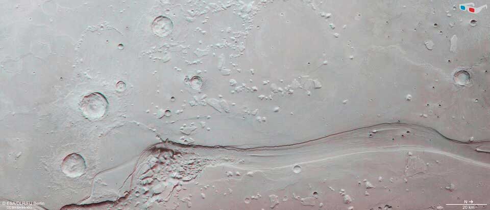
Martian valley of Shalbatana in 3D. ESA
Researchers visited this part of the Red Planet in October 2025, releasing a video journey by Mars Express that traced this gently winding channel from its beginning (the mountainous region of Xanthe Terra) to its end (the more level lowlands of Chryse Planitia), the European Space Agency press service reported.
The Shalbatan Valley formed approximately 3.5 billion years ago when massive volumes of groundwater rose to the surface of Mars. These catastrophic floodwaters cut through the rocks and rushed downward, quickly creating winding, water-eroded valleys. The main valley, which meanders from the lower left and extends northward out of the frame, is approximately 10 km wide and 500 m deep—this is most clearly visible in the accompanying topographic image.
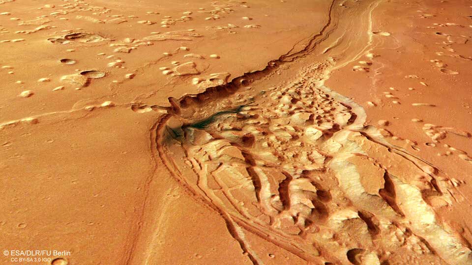
Aerial view of a small, chaotic area in the Shalbatana Valley. ESA
The Shalbatan Valley was likely deeper in the past, but over time it filled with various materials. While the exact materials that filled the valley are unknown, in the most hummocky part of the riverbed, one isolated patch of more recently deposited blue-black material can be seen: volcanic ash blown by Martian winds, as shown in the accompanying 3D perspective images.
Vallis Shalbatana is one of many similar valleys located in this region. This part of Mars separates the planet’s heavily cratered southern highlands from the more gently sloping northern lowlands. Beyond the frame is the aforementioned Chryse Planitia, one of the lowest parts of the entire planet. Many of Mars’s largest outflow channels terminate in Chryse Planitia, suggesting that at some point in Mars’s warmer and wetter history, it may have been covered by a significant ocean.
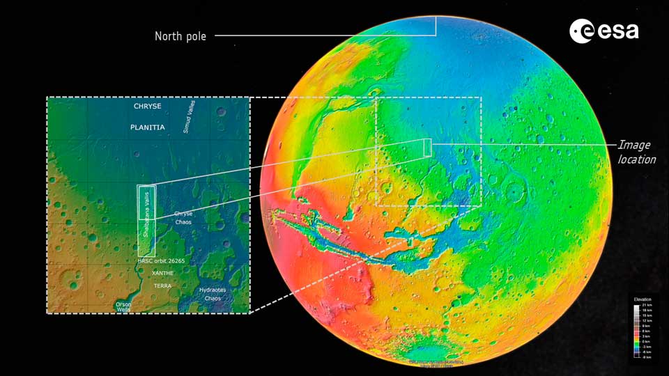
Where is the Shalbatan Valley on Mars? ESA
Outflow channels are typically found near so-called chaotic terrain—a labyrinthine collection of uplifted blocks and rock mounds. Chaotic terrain can be seen in the wider part of the Shalbatana Valley, adjacent to a dark layer of volcanic ash. It is thought to form when water ice trapped beneath the surface begins to melt, causing ground displacement and, ultimately, collapse. This type of terrain is common on Mars and has previously been imaged by Mars Express in regions such as Pyrrha Regio, Jani Chaos, Ariadnes Colles, Aram Chaos, and—in video—Hydraotes Chaos.
Numerous impact craters can also be seen here. Some are buried beneath a layer of rock, some are eroded, and others are surrounded by layers of material ejected during the initial impact that created the craters. Overall, the terrain is relatively flat, indicating that it was flooded by lava; in places, this lava was crumpled and folded as it cooled and compressed, forming jagged “wrinkle ridges.” Individual mesas (mesas)—remnants of a once-higher surface that has eroded over time—are also visible.
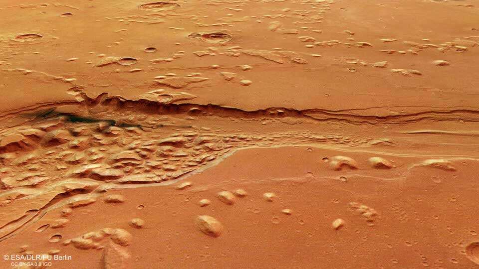
Aerial view of the Shalbatan Valley on Mars. ESA
Since its launch in 2003, Mars Express has been imaging and exploring the diverse landscapes of Mars. For over two decades, the orbiter has been mapping the planet’s surface with unprecedented resolution, in color and in three dimensions, obtaining data that has fundamentally changed our understanding of our planetary neighbor. The Mars Express HRSC spacecraft was developed and operated by the German Aerospace Center (DLR). Systematic processing of the camera data was carried out at the DLR Institute for Space Research in Berlin-Adlershof. The Planetology and Remote Sensing Working Group at the Free University of Berlin used this data to create the images presented here.
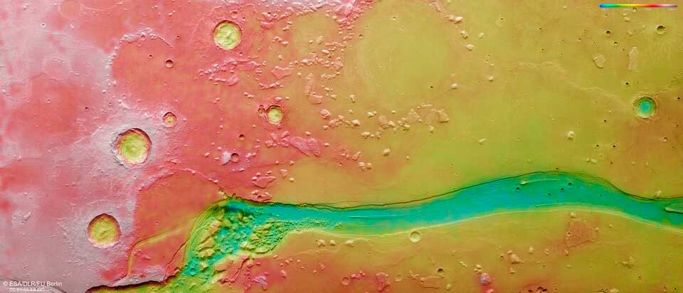
Topographic map of the Shalbatana Valley on Mars. ESA
The Curiosity rover discovered traces of Mars’s aquatic past in rocky “webs.” These web-like formations are believed to have been formed by ancient groundwater, providing new clues about the Red Planet’s aquatic past.
NASA’s Curiosity rover has captured close-up images of vast, web-like rock formations on Mars that look like giant spider webs from orbit and could provide new clues about the Red Planet’s watery past.
These complex formations are part of a narrow, box-shaped region—a network of low ridges roughly 1 to 2 meters high with sandy basins between them—that the Curiosity rover has been exploring for several months on the slopes of Mount Sharp inside Gale Crater. On September 26, 2025, the rover captured panoramic images of the region with its Mastcam camera, giving scientists an unprecedented look at the planet’s unusual topography, according to a statement from NASA’s Jet Propulsion Laboratory (JPL).
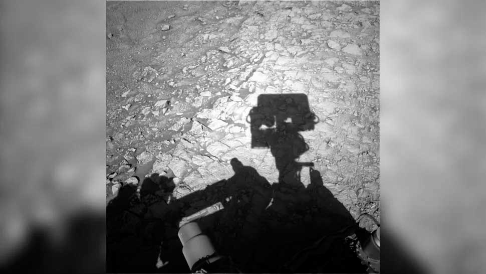
A grayscale image showing the shadow of NASA’s Curiosity rover on the surface of Mars, with its square Mastcam head superimposed on the rocky, box-shaped patterns of the Martian landscape. NASA/JPL-Caltech
From orbit, the intersecting ridges resemble a vast web stretching across the surface of Mars. Scientists believe the ridges formed when ancient groundwater circulated through cracks in the rock, depositing minerals that hardened certain zones. Over billions of years, wind erosion eroded the weaker surrounding material, leaving behind a network of stronger ridges.
Studying these formations could help researchers clarify the chronology of liquid water near the surface of Mars—a key factor in assessing whether Mars was habitable in the past. According to the statement, the web-like formations suggest that groundwater was present on Mars later than previously thought, raising new questions about how long the planet could have supported conditions favorable for microbial life.
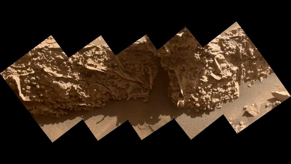
These lumpy nodules formed from minerals left behind when groundwater dried up on Mars billions of years ago. NASA’s Curiosity rover captured these pea-sized features while exploring geological formations called “box structures” on August 21, 2025. NASA/JPL-Caltech/MSSS
Before Curiosity arrived in the region, scientists couldn’t confirm what these web-like structures looked like up close or fully understand how they formed—only a rover on the ground could do that. But capturing such an image wasn’t easy: operators had to carefully maneuver the nearly ton-long rover along narrow ridges barely wider than the rover itself to obtain the necessary images.
A closer examination revealed pea-sized, lumpy mineral nodules embedded in the ridges and depressions—another sign of past groundwater activity. Surprisingly, these nodules were not concentrated near the central cracks, as expected, but scattered along the walls of the ridges and depressions, providing new insights into the interactions between water and minerals on the Martian surface.
Each layer of Mount Sharp, 5 kilometers (3 miles) high, reflects a distinct chapter in the history of Mars’s ancient climate. As Curiosity ascended, the topography showed a clear shift toward increasingly arid conditions, punctuated by periodic wetter periods when rivers and lakes briefly emerged on the surface.
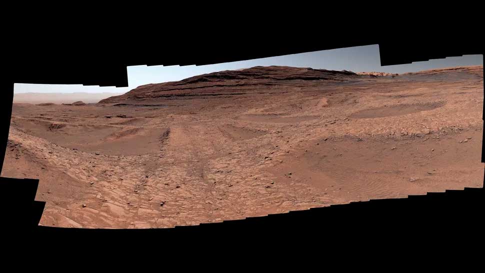
NASA’s Curiosity rover captured this panorama with its Mastcam instrument on September 26, 2025, revealing new details of the spiderweb-like ridges on Mount Sharp, including narrow mineralized ridges and the sandy basins between them. NASA/JPL-Caltech/MSSS
“Finding a box-shaped structure at such a high altitude in the mountains suggests that the groundwater level must have been quite high,” said Tina Seager, a mission scientist from Rice University, in a statement. “This means that the water needed to support life may have been available for much longer than we expected from observations from orbit.”
The Curiosity rover also used its drill to collect rock samples from the region, which resembles a closed massif. Analysis of these samples revealed the presence of clay minerals on the ridgetops and carbonate deposits in the basins—chemical signatures that shed light on the environmental conditions in which these rocks formed.
Using a technique called “wet chemistry”—a process in which chemical reagents help detect organic molecules—scientists searched for signs of carbon-containing compounds associated with life in crushed rocks collected during the Curiosity rover’s recent fourth sampling mission. Studying this region helps scientists better understand how the Red Planet evolved from a wet world to the cold, dry desert we see today.
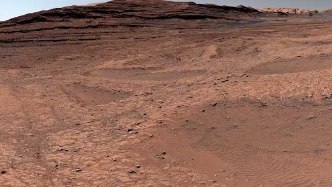
NASA’s Curiosity rover captured this panorama with its Mastcam instrument on September 26, 2025, revealing new details of the spiderweb-like ridges on Mount Sharp, including narrow mineralized ridges and the sandy basins between them. NASA/JPL-Caltech/MSSS
At Serpentine Rapids, Perseverance used its abrasive tool to create an abrasion zone in a red rock outcrop called “Wallace Butte” in Jezero Crater. The five-centimeter-thick abrasion zone revealed a striking combination of white, black, and green within the rock. One of the biggest surprises for the rover team was the presence of dull green patches within it, consisting of dark cores with fuzzy light green edges.
On Earth, red rocks, sometimes called “red beds,” typically get their color from oxidized iron (Fe3+), the same form of iron that makes our blood red, or the rusty red color of metal trapped outside. Green stains, like those seen in the Wallace Butte abrasion, are common in ancient “red beds” on Earth and form when liquid water percolates through sediment before it hardens into the rock, triggering a chemical reaction that converts oxidized iron to its reduced form (Fe2+), resulting in a greenish hue. On Earth, microbes are sometimes involved in this iron reduction reaction. However, green stains can also result from the decomposition of organic matter, which creates localized reducing conditions. Interactions between sulfur and iron can also create iron-reducing conditions without the involvement of microbial life.
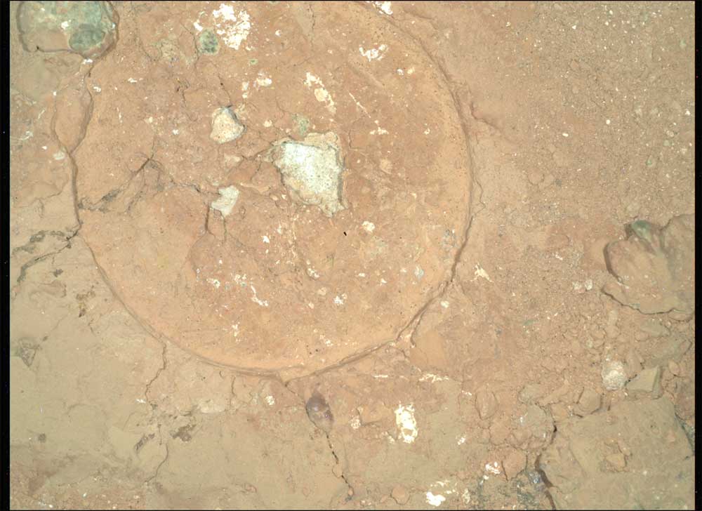
NASA’s Mars Perseverance rover captured this nighttime mosaic image of the Malgosa Ridge abrasion surface in the Serpentine Rapids region using the SHERLOC WATSON camera, located on a turret at the end of the rover’s robotic arm. The abrasion surface is 5 centimeters (about 2 inches) in diameter, and the large green spot in the upper left center of the image is approximately 2 millimeters (about 0.08 inches) in diameter. The original mosaic images have been debayered, flat-field transformed, and linearly color-stretched. This image was acquired on August 19, 2024 (sol 1243, or Martian day 1243, of the Mars 2020 mission) at 19:45:30 local mean solar time. NASA/JPL-Caltech
Unfortunately, there wasn’t enough space to safely position the rover’s robotic arm, carrying the SHERLOC and PIXL instruments, directly above one of the green spots on the abrasion surface, so their composition remains a mystery. However, the team is constantly searching for similar interesting and unexpected features in the rocks.
An ancient ocean and a giant lake on Mars
A massive bathtub-shaped geological structure on Mars may be evidence of an ocean that once covered a third of the Red Planet’s surface, according to another study.
Years of research have shown that, although Mars is now known as the “Red Planet,” liquid water once existed on its surface. However, it remains unclear whether this water was limited to lakes and streams, or whether it was sufficient to form long-lived oceans. Unraveling this mystery could shed light on whether life as we know it ever existed on ancient Mars.
Previous missions to Mars have discovered numerous geological features resembling coastlines. However, these coastlines are located at varying elevations across the planet. If they were truly signs of a stable ocean, they would ideally all be located at the same elevation, similar to how sea level remains constant on Earth.
In a new study, scientists looked for other geological features that could serve as signs of vanished Martian oceans. Using computer modeling, they effectively drained Earth’s oceans to see what features remained. They detailed their findings in an online publication on April 15, 2026, in the journal Nature.
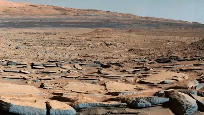
NASA/JPL-Caltech
Scientists have discovered that the most characteristic feature of Earth’s oceans, other than water, are flat strips of land up to several hundred miles wide, with elevations ranging from 50 to 1,345 feet (15 to 410 meters) below sea level. These strips, known as coastal plains and continental shelves, curve around the boundaries of land and ocean, like the ring left on a drained bathtub.
Sea levels on Earth and the location of coastlines have fluctuated over many years. In contrast, researchers found that coastal shelves remained relatively stable over time.
Scientists then analyzed topographic data from Mars’ orbiters. They discovered a flat zone on Mars that indicated a coastal ocean shelf in the northern hemisphere of Mars, covering a third of the planet’s surface. It would have existed at depths of approximately 1,800 to 3,800 meters (5,900 to 12,470 feet) below the Martian sea level.
A coastal shelf of this size would have taken a long time to form, and it’s not found near lakes. These new data suggest that an ocean on Mars must have existed stably, perhaps for millions of years.
Furthermore, the researchers found evidence that river deltas—triangular plains of sedimentary rock formed where rivers flow into the oceans—are aligned with the coastal shelf. On Earth, deltas are also concentrated on continental shelves.
Future missions could analyze this coastal shelf on Mars. If life once existed on the Red Planet, sedimentary deposits on the coastal shelf could preserve evidence of its existence, similar to how fossils from continental deposits are sometimes found in coastal deposits on Earth, the researchers noted.
Mars once harbored a lake larger than any other on Earth. The eroded and dried-up remains of this ancient lake are shown here in stunning detail, captured by the European Space Agency’s Mars Express spacecraft.
This region of Mars, captured in a new image by the Mars Express High Resolution Stereo Camera (HRSC), is known as Caralis Chaos. Scientists believe it once harbored abundant water, the European Space Agency press service reported in 2024.
The remains of an old lake bed are visible at the bottom of the frame (most clearly visible in the topographic image below, where it is shown in blue tones). The edges of this lake bed curve upward and extend from the lower center of the frame to the upper right, encircling the large central crater.
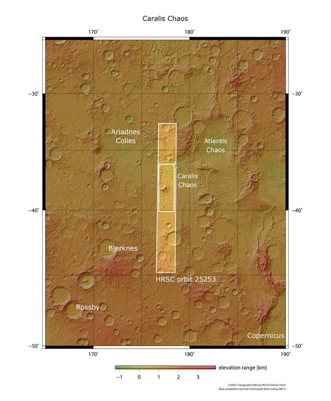
A wider view of the Karalis Valley. ESA
The old lake bed is now filled with numerous raised mounds, believed to have formed when ancient Martian winds blew dust across the planet; this dust was later covered and altered by water before drying out and crumbling again.
In the wider region surrounding Karalis Chaos, there are several old lake basins that have eroded over time. Together, these basins form the remnants of a vast ancient lake that covered over a million square kilometers: Lake Eridania.
Lake Eridania once contained more water than all other Martian lakes combined and was larger than any known lake on Earth, holding enough water to fill the Caspian Sea nearly three times. It likely existed about 3.7 billion years ago, first as a single large body of water and then, as it dried out, as a series of smaller, isolated lakes. Eventually, this once-massive lake disappeared completely, like all other water on the planet.
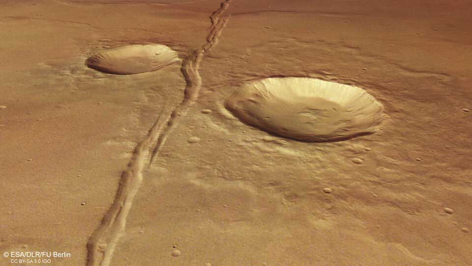
Perspective view. ESA
Besides water, there are clear signs of volcanic activity in and around the Karalis Chaos area.
In the image, two long cracks run vertically downwards, crossing both the aforementioned lakebed and the smoother surface to the left. These cracks, known as the Sirenum Fossa Fractures, were formed by the uplift of the Tharsis region of Mars, home to the largest volcanoes in the Solar System, placing enormous stress on the Martian crust.
Volcanic stress is also responsible for the numerous folds here. They appear as sinuous lines, intertwined horizontally across the frame. Folds are common on volcanic plains, formed when new lava layers are compressed while they are still soft and elastic, causing them to buckle and deform.
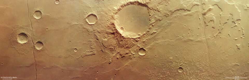
Karalis Chaos, imaged by the European Space Agency’s Mars Express. ESA
The impact craters formed by celestial bodies colliding with Mars are also fascinating. The large central crater shows evidence of material movement and valleys cut into its southern rim, suggesting that water may have persisted here even after Lake Eridania disappeared.
The smaller crater to the south is eroded by small gullies on its northern flank, while at the far right of the image are several ancient craters that can hardly be called craters, as they have been heavily eroded and eroded over time.
The Mars Express spacecraft has been orbiting the Red Planet since 2003. It is photographing the surface of Mars, mapping its minerals, determining the composition and circulation of its thin atmosphere, probing beneath its crust, and studying the interactions of various phenomena in the Martian environment.
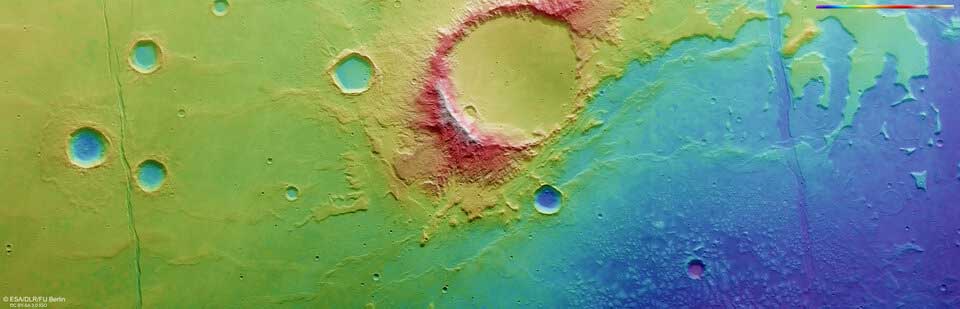
Topographical view. ESA
Over the past 20 years, the Mars Express High Resolution Stereo Camera (HRSC) has revealed countless details about the diverse surface of Mars. Its images capture everything from wind-driven ridges and valleys to karst sinkholes on the flanks of giant volcanoes, impact craters, tectonic faults, river channels, and ancient lava lakes. Over its lifetime, the mission has been remarkably productive, creating a far more complete and accurate picture of our neighboring planet than ever before. The Mars Express High Resolution Stereo Camera (HRSC) was developed and is operated by the German Aerospace Center (DLR).
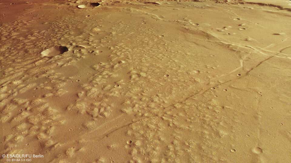
Perspective view. ESA
Russian and Chinese scientists have found evidence that an ocean once existed on Mars, according to a joint study published in the journal Scientific Reports. The scientists relied on data from China’s Zhurong rover, which has been operating in the southern part of Utopia Planitia on the Red Planet’s surface since 2021. It is believed that this is where the ancient ocean once existed.
“Remote sensing data from the Zhurong landing site suggest the possible existence of a single, permanent water/ice layer,” the authors write.
The study divided Utopia Planitia into sections and found that surface features are more or less dependent on the amount of water or ice present. The age of these features correlates with previous estimates of the age of the Martian ocean. According to the researchers, this ocean formed approximately 3.68 billion years ago and froze 3.42 billion years ago—a short period of time in geological terms.
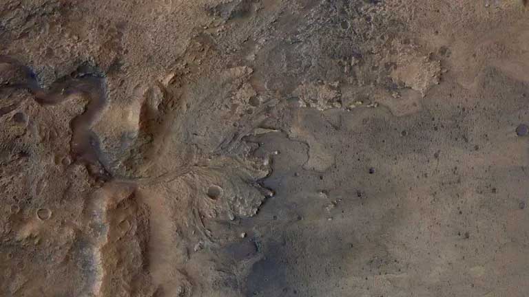
Mars. File photo. ESA/DLR/FU-Berlin
The study involved experts from the Hong Kong Polytechnic University, the China Academy of Space Technology, and the Russian Academy of Sciences.
China’s first spacecraft, Tianwen-1, consisting of an orbiter, landing capsule, and rover, launched on July 23, 2020, from the Wenchang Satellite Launch Center on Hainan Island. On May 15, 2021, the Zhurong rover successfully soft-landed on Utopia Planitia. The mission’s primary goal is to search for possible signs of life on Mars and help scientists understand whether conditions on the planet could change in the future to make it habitable for humans.
China became the first country in the world to complete a flyby and landing on Mars in a single mission, as well as conduct exploration of the Red Planet using a rover.
Subsequent comparison of the calculation results and images from Zhurong and orbital probes showed that all of these structures were formed as a result of water action, with some of them forming in presumably shallow waters and near the ocean coastline, and others in the deep regions of its bottom.
See also... New method for observing individual atoms confirms century-old quantum mechanical theory |
“Our analysis of Zhurong data and images indicates the existence of two sets of landforms associated with water on Utopia Planitia. Both were formed by the flooding of this lowland at the end of the Noachian, approximately 3.65 billion years ago. Approximately 3.58 billion years ago, water reached the so-called Deuteronile Line and formed the coastline,” the researchers write.
The discovery was made by a team of Chinese and Russian planetary scientists led by Wu Bo, a professor at the Hong Kong Polytechnic University, during a comprehensive study of the region of Utopia Planitia where Zhurong landed in May 2021. To do this, the researchers analyzed images and data collected by the NaTeCam camera, as well as the MarSCoDe and MSCam instruments on board the Chinese rover, as well as measurements taken by the American Mars Reconnaissance Orbiter (MRO) and Mars Global Surveyor (MGS).
Scientists’ interest in this region stems from its location on the southern edge of the so-called Vastitas Borealis, the largest Martian lowland, which is believed to be the floor of an ancient ocean. For this reason, many planetary scientists have long speculated that Utopia Planitia and the Deuteronile Line running through it are part of the coastline of this long-vanished body of water.
To test this theory, researchers comprehensively studied approximately half a million craters and tens of thousands of landforms located at the Zhurong landing site, including numerous crevasses, fissures, and so-called “pit cones”—hills that may be the remnants of mud volcanoes. To uncover their nature, the scientists created several computer models of Mars, describing different scenarios for the formation of these structures.
Subsequent comparison of the calculation results and images from Zhurong and the orbital probes revealed that all these structures were formed by water action, with some forming in presumed shallow waters and near the ocean’s shoreline, while others formed in deeper regions of the ocean floor. This analysis also confirmed that the Deuteronyl line is an ocean shoreline, the researchers concluded.
The Zhurong rover is the centerpiece of China’s Tianwen-1 Mars mission, which was launched to the fourth planet in the Solar System in July 2020. In February 2021, the rover reached Mars’ orbit, and in May, it landed on Utopia Planitia. In the following months, Zhurong studied the structure of the Martian subsurface and analyzed the composition of rocks until May 2022, when a powerful dust storm caused the rover to enter hibernation mode and stop responding to signals from Earth.
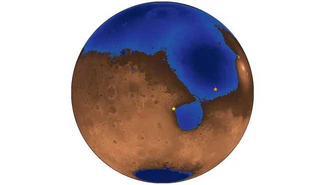
A hypothetical photograph of Mars 3.6 billion years ago, when an ocean may have covered nearly half the planet. The blue areas show the depth of the ocean, which filled the surface to the shoreline of an ancient, now-vanished sea known as Deuteronyl. The orange star marks the landing site of China’s Zhurong rover. The yellow star marks the landing site of NASA’s Perseverance rover, which landed a few months before Zhurong. Robert Citron
Zhurong spent a year, from May 2021 to May 2022, driving along the base of a steep rock outcrop at the edge of a wide, flat plain. It’s difficult to tell from the rover’s perspective on Earth, but this ancient coastline on Mars appears to have been located within a 2,050-mile-wide (3,300-kilometer-wide) impact crater called Utopia Basin. Utopia Basin is, in fact, the largest known crater in the entire solar system. Scientists have speculated that Utopia Basin may have once contained an ancient ocean, and they believe the escarpment overlooking Zhurong’s route may have once been its shoreline.
Along the Zhurong probe’s 1.9-kilometer (1.2-mile) route, its ground-penetrating radar transmitted radio waves 80 meters (262 feet) deep into the Martian soil. The reflection of these radio waves back to the instrument revealed the subsurface structures they touched, such as the boundaries between layers of rock and sediment. At a depth of 10 meters (33 feet), the radar revealed smooth, gently sloping layers of sand several yards (about 1.2 meters) thick. These layers appear to run parallel to the rocky cliff and rise toward it at a slight 15-degree slope, typical of beaches on planet Earth. The researchers published their results in the journal Proceedings of the National Academy of Sciences in 2024.
The buried beach may be the first evidence of a true ocean from Mars’s distant past, and its presence means that an ocean must have existed on the Red Planet for millions of years—long enough to leave behind the thick layers of sand recorded by the Zhurong radar. This ocean, scientists believe, must have been fed by rivers, as these rivers deposited sediment into the ocean. Eventually, waves carried the sediment along the shore, forming a beach strikingly familiar to us.
Underground water on Mars
Thanks to a seismometer installed onboard NASA’s InSight spacecraft, vast reserves of water were discovered deep beneath Mars in 2024. NASA’s InSight mission discovered enough water in the Red Planet’s crust to cover the surface of Mars in an ocean one to two kilometers (0.62 to 1.24 miles) deep.
InSight, which operated as a stationary lander, landed in Elysium Planitia on Mars in November 2018. It carried out its mission for four years and, equipped with the first seismometer ever delivered to the Red Planet, recorded 1,319 marsquakes.
Geophysicists Vashan Wright and Matthias Morzfeld from the Scripps Institution of Oceanography at the University of California, San Diego, and planetary science professor Michael Manga from the University of California, Berkeley, used seismometer data to detect water on the planet. The results of the study were published on August 12, 2024, in the Proceedings of the National Academy of Sciences.
They combined the various velocities of recorded marsquakes, determined by their reflections from the Red Planet’s interior, with a mathematical model describing the physics of various rock types in the Martian crust and mantle. This is the same model seismologists use on Earth to detect underground aquifers and oil fields.
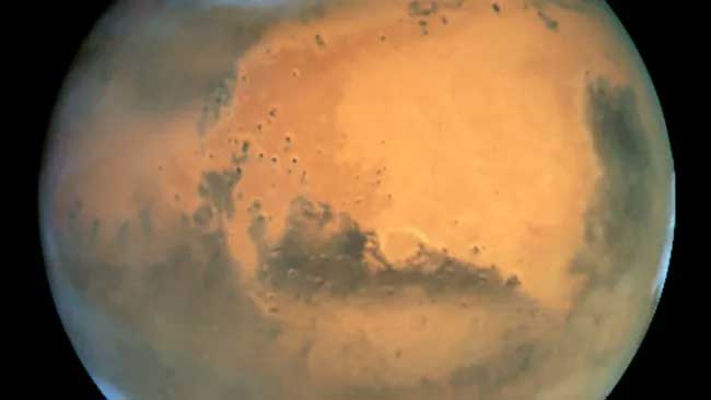
Deep inside Mars lies at least an entire ocean of water. STScI/AURA
The results were stunning, as the data showed that many of the seismic waves passed through rocks saturated with liquid water.
“Understanding the water cycle on Mars is critical to understanding the evolution of the planet’s climate, surface, and interior,” Wright said in a press release. “Determining where and how much water is present will be a useful starting point.”
However, it is now becoming clear that not all of Martian water was irretrievably lost. Some of it may have seeped into the Earth’s crust, where it accumulated in tiny cracks and pores in the planet’s fractured igneous rocks.
The problem is that this water is deep. Really deep. Seismic data shows it’s present at depths of 11.5 to 20 kilometers (7.1 to 12.4 miles), and there’s no water at all in the Earth’s crust below 5 kilometers (3.1 miles). So, despite this being the most compelling evidence to date of liquid water on Mars, it’s impossible for astronauts to reach it.
To illustrate why this is so unattainable, consider that the deepest hole ever drilled on Earth is the Kola Superdeep Borehole in Russia. Engineers in the Soviet Union spent 20 years drilling it, attempting to reach the Earth’s mantle, but had to abandon the drilling at a depth of 12.2 kilometers (7.6 miles) because the temperature became too high—180 degrees Celsius (356 degrees Fahrenheit)—for the drill bit. It’s unlikely that similar drilling will be possible on Mars anytime soon.
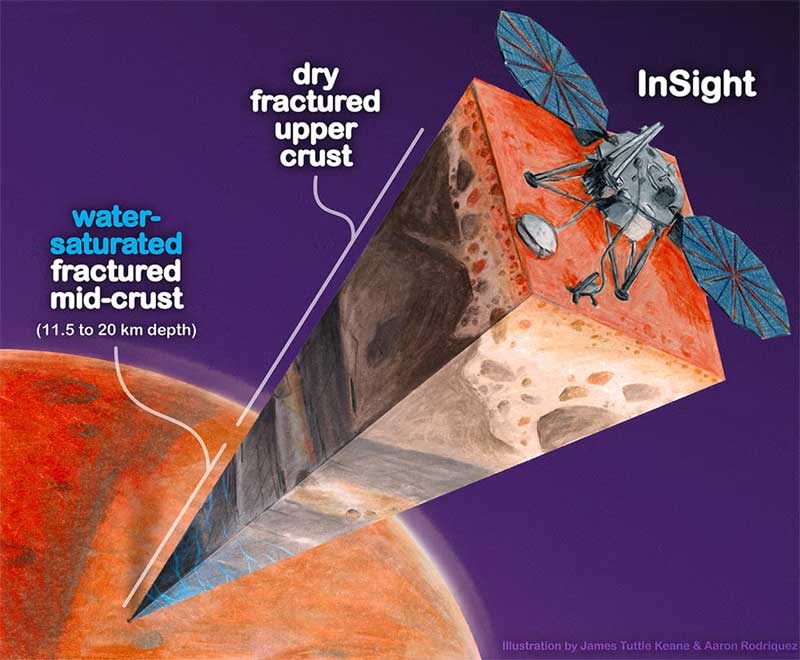
A piece of Martian crust showing fractured igneous rock containing water. Scripps Institution of Oceanography
But even if we can’t yet get to this water, we can speculate about its influence both on the history of Mars and on the possibility of life on the Red Planet.
“The discovery of a large reservoir of liquid water gives some clue as to what the climate was or might have been,” Manga said. “And water is essential for life as we know it. I don’t see why an underground reservoir wouldn’t be a habitable environment. That’s certainly true on Earth—life exists in deep mines, and there’s life on the ocean floor, too. We haven’t found any evidence of life on Mars, but at least we’ve found a place that, in principle, should be suitable for supporting life.”
A parallel study has shown that seismic data suggests that there may be an ocean of water beneath the surface of Mars.
Analysis of seismic data from NASA’s InSight lander has found compelling new evidence supporting the possibility of liquid water deep underground on Mars.
In 2024, researchers proposed that the Red Planet’s deep interior, particularly at depths between 7.1 and 12.4 miles (11.5 and 20 kilometers), is saturated with liquid water. They reached this conclusion based on seismic wave velocities detected during Marsquakes.
Researchers Ikuo Katayama of Hiroshima University and Yuya Akamatsu of the Research Institute of Marine Geodynamics in Japan have found evidence supporting the existence of liquid water deep within Mars. “Many studies indicate the presence of water on ancient Mars billions of years ago,” Katayama stated. “But our model indicates the presence of liquid water on modern Mars.” Katayama and Akamatsu’s study was published in the journal Geology in March 2025.
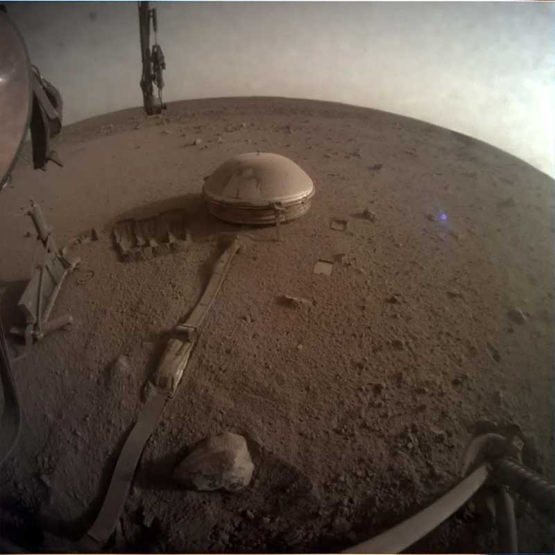
The InSight seismometer on the Martian surface, as imaged by the camera on board the lander. NASA/JPL–Caltech.
Like the previous study, this one is based on seismic data collected by the SEIS (Seismic Experiment for Interior Structure) instrument, which was part of the InSight mission that operated on the surface of the Red Planet from 2018 to 2022.
SEIS was the first seismometer to operate on Mars. It was sensitive to three different types of seismic waves generated by marsquakes: compressional waves, which oscillate back and forth like a sound wave; shear waves, which oscillate up and down perpendicular to the direction of propagation; and surface waves, which propagate across the Martian surface like ripples on a pond.
The new study focused on subsurface compressional and shear waves. Compressional waves are faster seismic waves, while shear waves are slower and cannot propagate in water, as the fluid prevents such oscillations perpendicular to the motion. Seismometers that measure these two different types of seismic waves can help determine the density and composition of the subsurface medium (such as water or rock) through which these waves traveled, based on the intensity of their signals and the time it took for them to reach the seismometer.
With this in mind, Katayama and Akamatsu focused on two transition regions in the seismic data that appear to show abrupt changes in the properties of the Red Planet’s interior at depths between 6.2 and 12.4 miles (10 and 20 kilometers), very close to where previous studies have claimed to have found evidence of liquid water.
Geophysicists have previously argued that these transitions reflect differences between volcanic materials above and impact ejecta buried below, as well as a change from porous rock (meaning filled with cracks and voids) to solid rock at depths of 12 miles (20 kilometers).
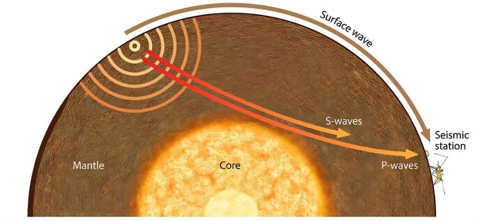
A diagram showing how different seismic waves propagate across Mars. Ikuo Katayama
But according to Katayama and Akamatsu, there’s more to it than that. Their analysis of longitudinal and shear waves recorded by SEIS shows that the porous rock contains water, filling cracks and cavities 10 to 20 kilometers deep.
To test their hypothesis based on seismic data, the two researchers tested diabases (a type of igneous rock also known as dolerite) from Rydaholm, Sweden. These rocks are among the best terrestrial analogs of Martian rocks, and Katayama and Akamatsu found that under wet conditions, diabases produce seismic signals similar to those recorded by SEIS.
Previous studies have suggested that deep underground on Mars there may be enough water to cover the surface of the world’s oceans to a depth of 1 to 2 kilometers. Confirmation of this amount of liquid water could indicate the possibility of “microbial activity,” Katayama said.
Comment on Facebook* The owner of the Meta company is recognized as extremist in Russia and is banned.See also... Complete list of HTML/Javascript event handlers with examples List of required documents for a website in the Russian Federation |